

Introduction:
National Highway 66 (NH 66) is a vital arterial road in India, playing a significant role in connecting various key cities and regions across the western coast of the country. Spanning approximately 1,600 kilometers, NH 66 is a crucial route that facilitates both economic and social activities in the states it traverses.
Overview of NH 66
1. Route and Connectivity
NH 66 extends from Panvel in Maharashtra to Kanyakumari in Tamil Nadu. This extensive highway covers a diverse range of terrains and regions, including urban centers, coastal areas, and rural zones. NH 66 connects several key cities and towns, including:
Cities by State
| Maharashtra | Goa | Karnataka | Kerala | Tamil Nadu |
|---|---|---|---|---|
| Panvel | Margao | Karwar | Kasaragod | Nagercoil |
| Mumbai | Panaji | Mangalore | Kannur | Kanyakumari |
| Ratnagiri | Udupi | Kozhikode | ||
| Kochi |
2. Strategic Importance
NH 66 is crucial for the economic development of the western coastal region. It facilitates the movement of goods and passengers, supporting trade and tourism. The highway also enhances connectivity between major ports and inland areas, boosting logistical efficiency.
Key Features of NH 66
1. Economic Impact
The highway’s strategic location enhances trade and commerce, particularly in the port cities of Mumbai, Mangalore, and Kochi. It supports industries like textiles, electronics, and pharmaceuticals, contributing to regional economic growth.
2. Tourism Development
NH 66 passes through several picturesque locations, including pristine beaches, historic sites, and cultural landmarks. Key tourist attractions along the route include:
- Goa: Known for its vibrant beach culture and historic forts.
- Kerala: Renowned for its scenic backwaters, picturesque hill stations, and rich traditional cuisine.
- Kanyakumari: Renowned for its unique geographical location where the Arabian Sea, Bay of Bengal, and Indian Ocean meet.
3. Infrastructure and Upgrades
Recent initiatives focus on upgrading NH 66 to improve road safety and reduce travel time. Projects include widening sections of the highway, enhancing road quality, and implementing modern traffic management systems. These upgrades aim to meet increasing traffic demands and provide a smoother driving experience.
National Highway 66 (NH 66) Overview
| Attribute | Details |
|---|---|
| Length | 1,640 km |
| Starting Point | Panvel, Maharashtra |
| Ending Point | Kanyakumari, Tamil Nadu |
| States Covered | Maharashtra, Goa, Karnataka, Kerala, Tamil Nadu |
| Number of Lanes | 4 to 6 |
| Maximum Speed | 120 km/h |
| Managing Authority | National Highways Authority of India (NHAI) |
| Expected Expansion Completion | November 2025 |
Also read: National Highway 10 (NH 31A): Route, Junctions, Benefits & latest news 2024
National Highway (NH 66) Route Map
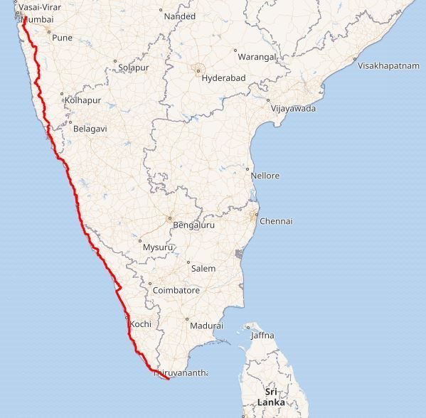
source: Imgur
Challenges and Solutions
1. Traffic Congestion
Certain stretches of NH 66 experience heavy traffic, especially in urban areas and during peak travel seasons. Solutions include constructing bypasses around congested cities and improving traffic management.
2. Environmental Impact
The development of NH 66 has environmental implications, particularly in sensitive coastal and forested areas. Sustainable practices and environmental assessments are crucial in mitigating adverse effects and preserving natural habitats.
3. Maintenance and Safety
Regular maintenance is essential to ensure the highway’s safety and functionality. This includes repairing potholes, ensuring proper signage, and implementing safety measures for pedestrians and vehicles.
Future Prospects
1. Expansion Plans
Future plans for NH 66 include further expansion and modernization to enhance its capacity and efficiency. This may involve integrating smart technologies and improving connectivity with other major highways and transport networks.
2. Economic Growth
As infrastructure projects progress, NH 66 is expected to drive substantial economic growth in the regions it serves. Increased accessibility will likely attract investment, stimulate local economies, and support job creation.
3. Environmental Sustainability
Efforts to balance development with environmental sustainability will be crucial. Implementing eco-friendly practices and technologies will help mitigate the highway’s environmental impact and promote long-term sustainability.
Also read: National Highway 6: Route map, Distance and Real estate Impact
States that lie on or are connected by National Highway 66
Cities by State
| States | No. of Cities | Name of Cities |
|---|---|---|
| Maharashtra | 14 | Panvel, Pen, Mangaon, Mahad, Poladpur, Khed, Chiplun, Sangameshwar, Ratnagiri, Lanja, Kankavli, Kudal, Sawantwadi, Rajapur |
| Goa | 3 | Margao, Canacona, Panaji |
| Karnataka | 10 | Karwar, Ankola, Kumta, Honnavar, Kapu, Mulki, Mangaluru, Bhatkal, Kundapura, Udupi, Kotekar |
| Kerala | 18 | Kannur, Kozhikode, Kochi, Neendakara, Kollam, Kottiyam, Chathannoor, Haripad, Kayamkulam, Karunagappally, Chavara, Kallambalam, Attingal, Kazhakkoottam, Neyyattinkara, Parassala, Thiruvananthapuram, Balaramapuram |
| Tamil Nadu | 3 | Kanyakumari, Marthandam, Nagercoil |
National Highway 66: Distances by State
Distances by State
| State | Distance (km) |
|---|---|
| Maharashtra | 475 km |
| Goa | 137 km |
| Karnataka | 294 km |
| Kerala | 678 km |
| Tamil Nadu | 56 km |
National Highway 66 serves as a vital link between India’s hinterland and its western coastline, connecting several major seaports. These ports are crucial for international trade and commerce, and NH-66 plays a pivotal role in facilitating the smooth movement of goods to and from these ports.
Key Sea Ports on the NH-66 Corridor
- Mumbai Port: One of India’s oldest and busiest ports, handling a vast volume of containerized and bulk cargo.
- Jawaharlal Nehru Port Container Terminal (JNPT): India’s largest container port, located in Navi Mumbai.
- Mormugao Port Trust (MPT): Situated in Goa, this port is a significant gateway for iron ore exports.
- New Mangalore Port Trust (NMPT): A major oil and petroleum product handling port in Karnataka.
- Cochin Port: A natural harbor that manages a diverse range of cargo, including containers, bulk goods, and liquid cargo..
- Kollam Port: An ancient port with growing importance in handling coastal trade and exports.
National Highway 66(NH 66): Project Status
| Aspect | Details |
|---|---|
| Project | Widening of NH 66 |
| Coverage | 24 sections between Kasargod and Thiruvananthapuram, spanning approximately 643 km in Kerala |
| Widening Specification | Road width will increase by 45 meters |
| Completion Schedule | Target completion by November 2025 |
| Current Status | 6 out of 23 reaches have been completed and opened for traffic |
| Ongoing Work | Work is underway on the remaining 17 reaches |
| Recent Actions | NHAI directed contracting companies to accelerate construction to boost state development |
| Oversight | NHAI Chairman personally checked progress and held meetings with contractors and engineers |
| Upcoming Connection | Completed Vyatila-Edappally stretch (16.75 km) will soon be connected to NH 66 |
Frequently Asked Questions:
NH 66 is a major national highway in India, extending from Panvel in Maharashtra to Kanyakumari in Tamil Nadu. It spans approximately 1,600 kilometers and connects various key cities along the western coast.
NH 66 traverses five states: Maharashtra, Goa, Karnataka, Kerala, and Tamil Nadu
The NH 66 widening project covers 24 sections between Kasargod and Thiruvananthapuram, spanning around 643 km in Kerala. It aims to increase the road’s width by 45 meters and is targeted for completion by November 2025
Out of 23 reaches, 6 have been completed and are open for traffic. Work is ongoing on the remaining 17 reaches
The Vyatila-Edappally stretch (16.75 km) has been completed and will soon be connected to NH 66
Suggested Articles:
National Highway 163: Routemap, Distance and Real Estate Impact
National Highway 6: Route map, Distance and Real estate Impact
National Highway 10 (NH 31A): Route, Junctions, Benefits & latest news 2024

 project. Discover recent developments, project scope, and how the widening will enhance connectivity across India.)