The Bangalore Metro Phase 2, an ambitious extension of Namma Metro, promises to enhance urban transport in Bengaluru significantly. Approved by the Karnataka state government in 2011 and the Central Government in 2014, this phase is set to extend the metro network by 73.921 km. Here’s a detailed look into the project’s scope, construction, and future impact.
Bangalore Metro Phase 2: Overview
Bangalore Metro Phase 2 is a pivotal development in enhancing Bengaluru’s urban transport system. Overseen by Bangalore Metro Rail Corporation Limited (BMRCL), Phase 2 incorporates both elevated and underground sections, significantly broadening the city’s metro network. Designed to alleviate the severe traffic congestion in Bangalore, Phase 2 aims to provide much-needed relief to its residents.
Commonly referred to as Namma Metro Phase 2, this ambitious project is currently underway. While some sections are already operational, others remain under construction. According to BMRCL’s latest projections, Phase 2 is expected to be completed by 2024. However, due to various factors, the full completion of the Bangalore Metro Phase 2 project may extend to 2025-2026.
Construction Timeline and Status
Start of Construction: September 2015
Expected Completion: 2026 (Phase 2 sections expected to open in stages)
Total Length: 73.921 km
Underground Section: 13.885 km
Elevated Section: Remaining length
Current Deadline: 2024 (BMRCL’s projection)
Estimated Completion: 2026
Major funding for Phase 2 comes from the European Investment Bank (EIB), Asian Infrastructure Investment Bank (AIIB), and possibly the Japan International Cooperation Agency (JICA).
New Lines and Extensions: Bangalore metro phase 2
Line-3: Yellow Line – RV Road to Bommasandra
- Length: 19.143 km
- Type: Elevated
- Depot: Hebbagodi Depot (39.3 acres)
- Number of Stations: 16
- Stations: Rashtreeya Vidyalaya Road, Ragigudda, Jayadeva Hospital, BTM Layout, Central Silkboard, Bommanahalli, Hongasandra, Kudlu Gate, Singasandra, Hosa Road, Beratena Agrahara, Electronic City, Infosys Foundation Konappana Agrahara, Huskur Road, Hebbagodi, Bommasandra
Line-4: Pink Line – Kalena Agrahara to Nagawara
- Length: 21.386 km
- Type: Elevated (7.501 km) and Underground (13.885 km)
- Depot: Kothanur Depot (31.5 acres)
- Number of Stations: 18
- Stations: Kalena Agrahara, Hulimavu, IIM-Bangalore, JP Nagar 4th Phase, Jayadeva Hospital, Swagath Road Cross, Dairy Circle, Lakkasandra, Langford Town, Rashtriya Military School, MG Road, Shivaji Nagar, Cantonment, Pottery Town, Tannery Road, Venkateshpura, Kadugundanahalli, Nagawara
Also read: Bangalore metro Phase 1: Complete Guide to Route map, Lines, Stations
Line Extensions
Line-1: Purple Line – Mysore Road to Challaghatta
- Length: 8.814 km
- Type: Elevated
- New Depot: Challaghatta Depot (38.9 acres)
- Number of Stations: 7
- Stations: Nayandahalli, Rajarajeshwari Nagar, Jnana Bharathi, Pattanagere, Kengeri Bus Terminal, Kengeri, Challaghatta
- Status: 7.5 km Mysore Road – Kengeri section opened on August 30, 2021; 2.1 km Kengeri – Challaghatta section opened on October 9, 2023
Line-1: Purple Line – Baiyyappanahalli to Whitefield
- Length: 15.257 km
- Type: Elevated
- New Depot: Kadugodi Depot (44.8 acres)
- Number of Stations: 13
- Stations: Benniganahalli, KR Pura, Singayyanapalya, Gurudacharpalya, Hoodi, Seetharamapalya, Kundalahalli, Nallurhalli, Sri Sathya Sai Hospital, Pattandur Agrahara, Kadugodi Tree Park, Hopefarm Channasandra, Whitefield
- Status: 13 km KR Pura – Whitefield section opened on March 26, 2023; 2.2 km Baiyyappanahalli – Benniganahalli – KR Pura section opened on October 9, 2023
Line-2: Green Line – Yelachenahalli to Silk Institute
- Length: 6.29 km
- Type: Elevated
- New Depot: Anjanapura Depot (8.9 acres)
- Number of Stations: 5
- Stations: Doddakallasandra, Konankunte Cross, Vajrahalli, Thalgattapura, Silk Institute
- Status: Inaugurated on January 14, 2021
Line-2: Green Line – Hesaraghatta Cross to Madavar
- Length: 3.031 km
- Type: Elevated
- Number of Stations: 3
- Stations: Manjunathanagar, Chikkabidarakallu, Madavar
- Status: Under Construction
Blue Line: Phase 2B (Airport Metro Line)
Phase 2B of the Bangalore Metro project is set to link Kempegowda International Airport with MG Road, covering a distance of 39 km. This line will commence at Krishnarajapura (KR Puram) and traverse the northern segment of the Outer Ring Road (ORR), passing through key areas such as Nagawara, Hebbal, and Jakkur before reaching the airport. With an estimated cost of ₹10,584 crores, Phase 2B is a major endeavor to enhance connectivity to the airport.
Upon completion, Phases 2A and 2B will greatly cut down travel times for Bangalore residents. The Blue Line along the ORR will address growing travel demands, providing efficient links between crucial areas like KR Puram and Silk Board. Moreover, the Airport Line will facilitate smoother transit from various parts of the city to Kempegowda International Airport, reducing commuting hassles.
Bangalore Metro Phase 2 Project Cost
Originally estimated at ₹26,405 crores based on 2011-12 price levels, the cost of Namma Metro Phase 2 is projected to rise to ₹32,000 crores due to an annual escalation rate of approximately 5%. The State Government has committed ₹9,000 crores, with any additional increases beyond central levies to be shared between the Union Government, the State, and Bangalore Metro Rail Corporation Limited (BMRCL).
| Aspect | Details |
|---|---|
| Initial Estimated Cost (2011-12) | Rs 26,405 crore |
| State Government’s Contribution | Rs 9,000 crore |
| Annual Escalation Rate | Approximately 5% per year |
| Estimated Total Cost (Projected) | Rs 30,000 – Rs 32,000 crore |
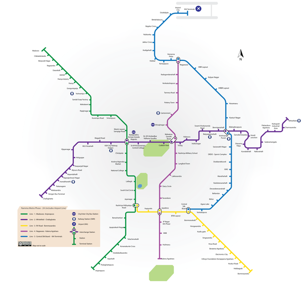
Bangalore metro phase 2: Route map

source: Wikimedia
Namma metro phase2 : Impact and Future Prospects
Enhanced Connectivity: The extension will link major parts of Bengaluru, improving access to commercial and residential areas.
Reduced Congestion: With new lines and extensions, the metro network will alleviate traffic congestion on key roads.
Economic Benefits: Increased property values and new business opportunities are expected along the extended lines.
Environmental Impact: By promoting public transport, Phase 2 will contribute to reduced pollution and a smaller carbon footprint.
Future Developments: The success of Phase 2 will pave the way for further expansions, enhancing Bengaluru’s metro network and setting a benchmark for urban transit systems in India.
Conclusion
Bangalore Metro Phase 2 represents a significant leap forward for urban mobility in Bengaluru. With extensive new lines and crucial extensions, the project will transform the city’s transport landscape, making commuting more efficient and environmentally friendly. As Phase 2 progresses, it will continue to offer significant benefits, reinforcing Bengaluru’s position as a modern metropolitan hub.
Frequently Asked Questions:
Bangalore Metro Phase 2 is an extension of the Namma Metro network, designed to enhance urban transport in Bengaluru. This phase adds 73.921 km of new routes, combining both elevated and underground sections to improve connectivity across the city.
The project was approved by the Karnataka state government in 2011 and the Central Government in 2014.
The Bangalore Metro Rail Corporation Limited (BMRCL) projects Phase 2 to be completed by 2024. However, due to various factors, the overall completion might extend to 2026.
The initial estimated cost of Phase 2 was ₹26,405 crores. With an annual escalation rate of about 5%, the total cost is projected to rise to ₹32,000 crores. The State Government has allocated ₹9,000 crores, with additional costs to be shared by the Union Government and BMRCL.
Suggested Articles:
Bangalore metro Phase 1: Complete Guide to Route map, Lines, Stations
Bangalore Metro Route: Gree, pink, yellow, Blue, Purple and Orange line, timings, stations 2024
Baiyappanahalli Metro Station Bangalore: Route map, Timings and Real estate


